Alcântara, Maranhão
Alcântara | |
|---|---|
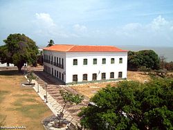
 Alcântara government building | |
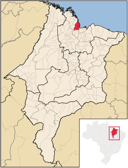
 Location in Maranhão state | |
| Coordinates: 02°24′32″S 44°24′54″W / 2.40889°S 44.41500°W | |
| Country | Brazil |
| Region | Northeast |
| State | Maranhão |
| Area | |
• Total | 1,458 km2 (563 sq mi) |
| Population (2020 [1]) | |
• Total | 22,112 |
| • Density | 15/km2 (39/sq mi) |
| Time zone | UTC−3 (BRT) |
| Postal code | 65250-000 |
| Area code | +55 98 |
Alcântara is a Brazilian municipality in the state of Maranhão. The municipality has a population of 22,112 (2020) and an area of 1458 km2. The municipality is 30 km away from the state's capital, São Luís.
History
[edit]Founded by French explorers in the 16th century, Alcântara was later conquered by the Portuguese, who used the small village as a base to take São Luís from the Dutch in 1646.
Helton da Silva Arruda, a famous Brazilian goalkeeper, was born in the town.
Geography
[edit]The town was declared by the Brazilian government as a National Historical Patrimony. The town's economy is based mainly on tourism and fishing.
The climate is favorable, characterized by two well-defined seasons: a rainy season from January to June, and a dry season from July to December. The annual average temperature is 26.5 °C, and the wind blows predominantly from the east at an average speed of 12 m/s.

The municipality contains a small part of the Baixada Maranhense Environmental Protection Area, a 1,775,035.6 hectares (4,386,208 acres) sustainable use conservation unit created in 1991 that has been a Ramsar Site since 2000.[2]
Demography
[edit]Alcântara is the municipality with the largest number of quilombola communities in Brazil, with more than 200 communities.[3]
With the economic decline, the drop in exports and the shift of production to the valleys of the Itapecuru, Mearim and Pindaré Rivers, land was abandoned by the owners of large farms and by the religious orders of the Carmelite Order, the Jesuits, the Carmelites and the Mercedarians, who also owned land in Alcântara, leading the black population to promote other forms of organization and occupation of the territory.[3]
The expansion of the launch center has become a conflict point for the preponderance of quilombola communities. More than 300 families from 32 communities were forced from their homes during the construction of the launch center in the 1980s, and the federal government pursued plans to expand the center while denying land title to the quilombola communities.[4] In a ceremony on 19 September 2024, Luiz Inácio Lula da Silva signed two ordinances and a decree allocating 78,1 hectares of land in Alcântara to the quilombola communities for titling, a cancellation of the federal government's efforts to seize 12,6 hectares from the quilombolas for the launch center.[5]
In separate litigation brought by quilombola communities, the Inter-American Court of Human Rights ruled against Brazil's federal government and the Brazilian Armed Forces, ruling that the federal government violated the fundamental rights and compromised the “collective life project” of 171 quilombola communities during the installation and operation of the Alcântara military rocket launch base. The court ordered the government to grant title to the 78,1 hectares of traditional territory within three years, pay US$4 million to the residents' associations and carry out further acts of reconciliation with the communities.[6]
Infrastructure
[edit]Rocket Launch Center
[edit]The Brazilian Space Agency maintains a launch site near Alcântara.
The Alcântara launch center is located near the historic town of Alcântara, close to the city of Sao Luis, capital of the state of Maranhão. The geographic coordinates are 2°18′S and 44°22′W.
The launch center comprises the Cyclone-4 launch site, under the responsibility of ACS, and a set of facilities under the responsibility of the Brazilian Air Force (FAB), and the Brazilian Space Agency (AEB), which include general infrastructure and dedicated complexes for the launching of the Brazilian Satellite Launch Vehicle (SLV).
The overall infrastructure consists of an airport with a 2,600 meter-long runway, a Command and Control Sector equipped with telemetry, communication, meteorology, radar and electricity supply systems, and an Administrative center with hotels, a hospital and administrative buildings.
The general infrastructure also includes roads, and a project for a seaport which is currently underway.
Technical Complex
[edit]The main components of the Cyclone-4 launch site are the Technical Complex and the Launch Complex. The Satellite Assembly Integration and Testing Building is located in the Technical Complex. This building has clean rooms for receiving, testing, fuelling and satellite integration to the launch vehicle payload unit. This building is connected to the Launch Vehicle Assembly, Integration and Testing Building, where the launch vehicle parts are received and tested, and the entire vehicle assembled. The integration of the payload unit, already with the satellite, to the launch vehicle is performed in this building.
The Launch Complex receives the Cyclone-4 launch vehicle horizontally by a railway that connects the launch complex to the technical complex. The launch vehicle is tilted to the vertical position, and the final tests are performed automatically. The launch complex is designed so that the launch vehicle fuelling and launching are performed automatically, thus allowing a safe and reliable operation.
On August 22, 2003, an accident occurred when a VLS-1 rocket accidentally exploded, killing 21 Brazilian technicians.
References
[edit]- ^ IBGE 2020
- ^ APA Baixada Maranhense (in Portuguese), ISA: Instituto Socioambiental, retrieved 2016-06-13
{{citation}}: CS1 maint: publisher location (link) - ^ a b «Territories and Identities in the Remnant Quilombo Communities of Agrovila Peru in the Municipality of Alcântara – MA» (PDF)
- ^ Socioambiental, Instituto (2020-04-17). "Quilombolas de Alcântara sob ameaça: entre a pandemia e a remoção forçada". Medium. Retrieved 2025-04-18.
- ^ "Quilombolas reach agreement to regularize territory in Alcântara (MA) | Instituto Socioambiental". www.socioambiental.org. 2024-09-20. Retrieved 2025-04-18.
- ^ "In a historic decision, Brazil is convicted of violating the rights of quilombolas in Alcântara (MA) | Instituto Socioambiental". www.socioambiental.org. 2025-03-14. Retrieved 2025-04-18.


